femr2 Thursday, 28-03-2024, 16:47:09
Welcome Guest | RSS
[ New messages · Members · Forum rules · Search · RSS ]
  • Page 1 of 1
  • 1
Forum » WTC Impacts » UAL 175 / N175F » MSNBC Clip Shows TWO 'Flight 175' Aircraft (UAL175 & N175F)
MSNBC Clip Shows TWO 'Flight 175' Aircraft (UAL175 & N175F)
femr2Date: Saturday, 14-03-2009, 14:24:06 | Message # 1
Admin
Group: Administrators
Messages: 60
Reputation: 0
Aircraft tracking software being used by MSNBC within a live broadcast aired at ~10:26am on 9/11 2001. The broadcast time is known, as the descent of WTC 1 initiated during the 5 minute source clip. WTC 1 descended at ~10:28am.

The FlightExplorer software displays pop-up aircraft information when the mouse hovers over each aircraft position icon.

During the clip, TWO 'Flight 175' aircraft are seen.

UAL175 is positioned far beyond the WTC complex, traveling away from the Twin Towers, at a time after it should already be embedded within WTC 2.

It should be made clear that the position of UAL175 corresponds exactly with the final position of UAL175 on the globally released FlightExplorer flight-path animations. It may indicate the final 'tracked' position of the aircraft or atc track, rather than a specific real-time position. FlightExplorer simply displays positional data sent by the FAA. It is clear however, that the position is not a predicted or estimated position, but a physical position as fed to FlightExplorer by the FAA.
 
femr2Date: Sunday, 15-03-2009, 11:32:38 | Message # 2
Admin
Group: Administrators
Messages: 60
Reputation: 0
UAL175

UAL175Flight: UAL 175
318 438Altitude: 31800 feet, Speed: 438 knots
B762Aircraft: Boeing 767-200 series
BOS 08:15aDeparting Boston 08:15am
LAX 01:44pArriving LA 01:44pm

Position: ~50 km NE of WTC

 
femr2Date: Sunday, 15-03-2009, 11:34:52 | Message # 3
Admin
Group: Administrators
Messages: 60
Reputation: 0
N175F

N175FFlight: N175F
007 136Altitude: 700 feet
Speed: 136 knots
????
???? ?? ??

Position: WTC

 
femr2Date: Sunday, 15-03-2009, 15:26:02 | Message # 4
Admin
Group: Administrators
Messages: 60
Reputation: 0
From the FlightExplorer flightpath animations, and statements from the company who produce FlightExplorer, it is clear that the data is NOT predicted flightpath data, but is driven by radar data supplied by the FAA.

The FlightExplorer flightpaths were used by 11 news agencies on 9/11, and the FAA themselves regularly used FlightExplorer flightpath recordings until 1999, at which point they began recording them internally.

The FlightExplorer flightpaths include all deviations from the planned flightpath, confirming they are position based rather than predictive.

The FlightExplorer flightpaths produced by FlightExplorer themselves used their internal data, negating all client refresh timing updates, and so incorporate all FAA supplied positional data.

FlightExplorer received regular requests from the FAA themselves for flightpath traces, confirming the accuracy and validity of their data.

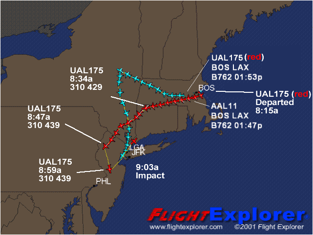
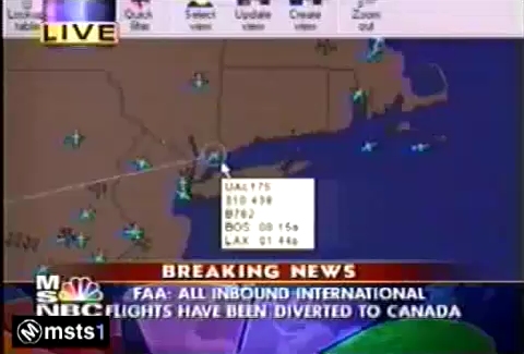
The label for UAL175 at 8:59am specifies the altitude is 31000 feet.

The following image contains the official altitude data for 'Flight 175':

"Flight 175" altitude at 8:59am should have been 22000 feet.

FlightExplorer data validity is clear. Why does the 'official' altitude data differ ? Could it be tracking a different aircraft ?

Here are some quotes from FlightExplorer themselves:

Quote
The actual screen refreshes every 10 seconds with any position changes that have been received in the previous 10 second window

Quote
How real-time is it?
Sabre Flight Explorer Professional users receive individual aircraft updates every minute. The Sabre Flight Explorer client software that you run from your PC receives updates from our servers every 10 seconds. This means that you receive fresh air traffic data every 10 seconds.

This quote clarifies that the client refresh rate back in 2001 was lower, but does not confirm whether the internal feed rate was any different:

Quote
Flight Explorer updates most aircraft positions once every 3 minutes. The actual screen refreshes every 10 seconds with any position changes that have been received in the previous 10 second window.

Quote
What type of data is supplied?

Sabre Flight Explorer provides the most accurate and reliable stream of air traffic data available in the industry. The data is based upon radar, satellite and other tracking information supplied by the FAA and other sources. Once Sabre Flight Explorer receives this data, it is processed and sent to the Sabre Flight Explorer client software via the Internet.

Source: FlightExplorer

Further relevant information on FightExplorer, including the flightpath traces released can be found here:
Flight Explorer Thread

 
femr2Date: Sunday, 15-03-2009, 19:20:31 | Message # 5
Admin
Group: Administrators
Messages: 60
Reputation: 0
From the information you have seen in this thread so far...

The FlightExplorer flightpath data seen in the MSNBC clip shows:

a) Flight UAL175 was positioned ~50 km NE of the WTC at 31800 feet
b) Flight N175F was positioned at the WTC at a height of 700 feet. Roughly the height that 'Flight 175' impacted WTC 2

The flightpath data for UAL175 includes two transponder frequency changes.

The FlightExplorer flightpath data shows unusual reduction in the number of data points following transponder frequency changes.

 
MattDate: Saturday, 28-03-2009, 16:40:41 | Message # 6
Private
Group: Users
Messages: 1
Reputation: 0
Good work, man. More info here, btw:

http://pilotsfor911truth.org/forum//index.php?showtopic=14399
http://z15.invisionfree.com/911taboo/index.php?showtopic=685&st=0

(first post - wooo! Nice forum here. Will bookmark.)


http://www.911conspiracy.tv
http://www.911conspiracy.tv/9-11_TV_archive.html
http://www.911conspiracy.tv/2nd_hit.html
 
ArrowHeadDate: Wednesday, 08-04-2009, 20:02:59 | Message # 7
Private
Group: Users
Messages: 3
Reputation: 0
The hijackers disabled the plane’s transponder, rendering tracking unreliable.

I’m only posting here because you blocked me from one of your YouTube videos for pointing that out.

You can fantasize, obscure through verbosity, and censor dissenting voices all you want, but it won’t change reality, and it only shows you for what you are.


9/11 Conspiracy Theories

Message edited by ArrowHead - Wednesday, 08-04-2009, 20:03:41
 
femr2Date: Wednesday, 08-04-2009, 20:22:12 | Message # 8
Admin
Group: Administrators
Messages: 60
Reputation: 0
No, ArrowHead, you were blocked for deliberate misdirection, and rudeness, even though I was being perfectly clear about the detail being discussed, which, as you are here, you have obviously now decided to check.

The questions being discussed were about the frequency at which FlightExplorer updates, which are clearly presented within these forums, and linked in to the video description on YT. Your constant argumentative stance stating that these matters are opinion based are totally wrong, as FlightExplorer themselves have published the appropriate information.

Such specific factual information is not 'fantasy'.

I do not enter into pointless never-ending conversation and unrelenting 'dissent' (which has little bearing on the video topic itself).

Your statement here is also factually incorrect.

The transponder frequency for UAL175 was changed, twice. It was at no point 'disabled'.

Again, deliberate misdirection and deliberately incorrect statements will also result in your removal from here also.

Good luck.

 
ArrowHeadDate: Wednesday, 08-04-2009, 20:54:11 | Message # 9
Private
Group: Users
Messages: 3
Reputation: 0
There you go again. You’re the one misdirecting and misinforming.

FlightExplorer is just a frontend for ASDI data and as such isn’t reliable second-to-second or even minute-to-minute. And given conflicting, errant or missing data, it will produce errant data. “Garbage in, garbage out”.

A member of the forum linked in my signature tells of how he was using FlightExplorer to track a flight his parents were on, and they phoned him from the gate while FlightExplorer was still telling him the plane was in the air.


9/11 Conspiracy Theories

Message edited by ArrowHead - Wednesday, 08-04-2009, 21:00:22
 
femr2Date: Wednesday, 08-04-2009, 21:04:54 | Message # 10
Admin
Group: Administrators
Messages: 60
Reputation: 0
I am very familiar with the thread you mention, which the final conclusion that the JREF users happily accepted was that the data showing N175F at the WTC location, at 700ft was information typed in by an ATC operator, denoting completely different information in the field which FlightExplorer clearly uses for altitude and airspeed.

The quote from your mentioned member carries absolutely no corroborating evidence, and as such does not constitute anything other than words.

I may actually go through said forum and highlight every single deliberate misdirection performed on that thread.

 
newtonDate: Tuesday, 28-07-2009, 21:33:43 | Message # 11
Private
Group: Users
Messages: 4
Reputation: 0
so, if "ual" is united airlines, what is airline is "N"?
 
femr2Date: Wednesday, 29-07-2009, 05:02:48 | Message # 12
Admin
Group: Administrators
Messages: 60
Reputation: 0
Quote (newton)
so, if "ual" is united airlines, what is airline is "N"?

The ID is in the form of the normal "N" number, but they are not normally shown in FlightExplorer, which display the Flight ID. (A totally different value)

There is no "N" airline. FlightExplorer never responded to requests for the raw data. I haven't managed to progress on the topic I'm afraid.

It's still an "unknown"...

 
newtonDate: Wednesday, 29-07-2009, 06:58:58 | Message # 13
Private
Group: Users
Messages: 4
Reputation: 0
suspicious? ....this unknown flight which is the flight that crashed into the tower?
everything is in order, i'm sure. nothing to see here, move along....
 
Forum » WTC Impacts » UAL 175 / N175F » MSNBC Clip Shows TWO 'Flight 175' Aircraft (UAL175 & N175F)
  • Page 1 of 1
  • 1
Search:

Copyright MyCorp © 2024Free web hostinguCoz